DEPARTMENT OF TOURISM, CULTURE,WILDLIFE,TRADE, AND INDUSTRY
PROFILES OF ATTRACTION SITES-ELGEYO MARAKWET.
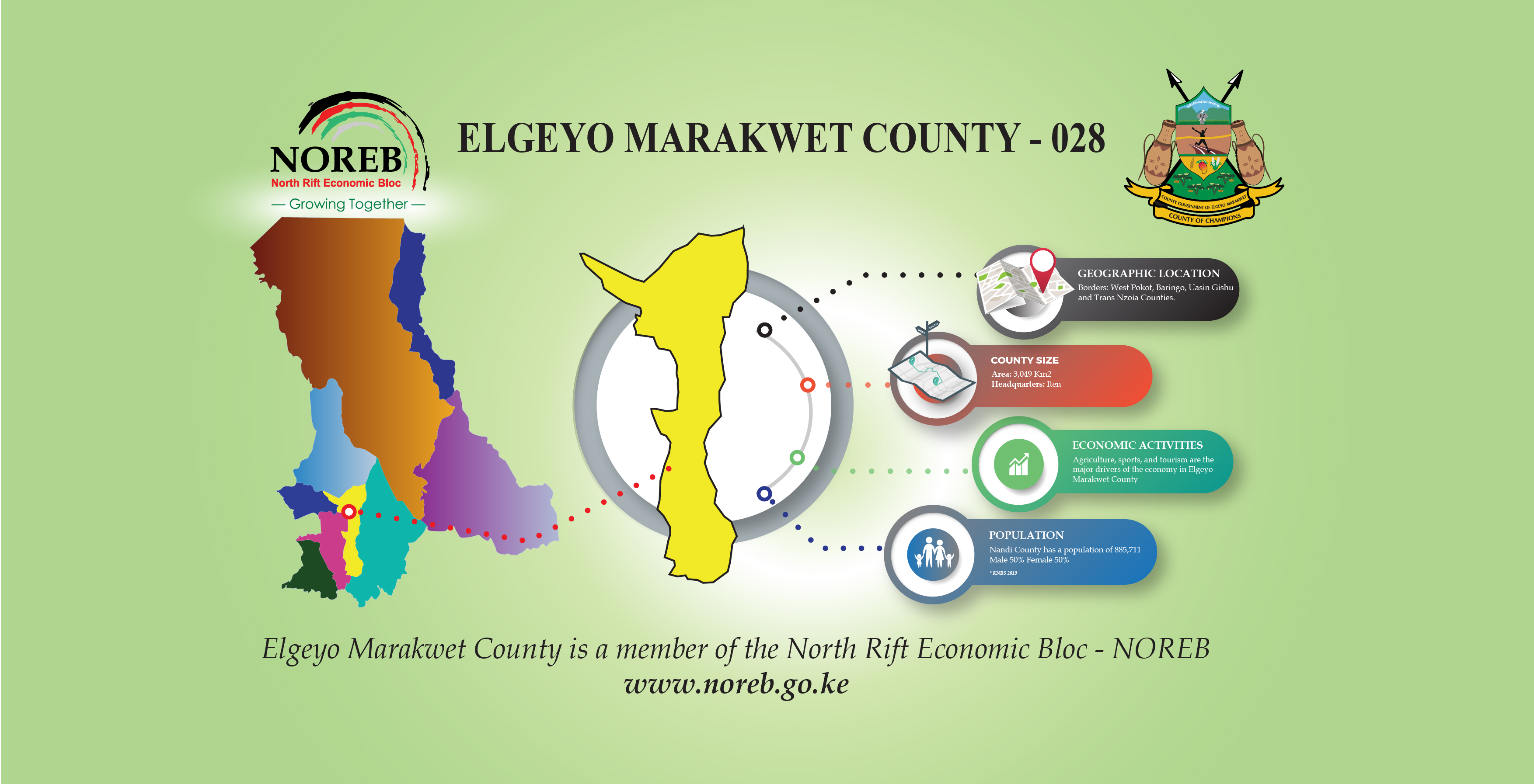
The County has huge untapped tourism potential associated with the dramatic Rift Valley landscapes, the cultural heritage and biodiversity.
The County has temperatures ranging between 14°C to 35 C. Rainfall ranges between 400mm and 1,400mm per annum. Economic activities in the county are characterised by mixed small scale farming and cattle rearing for both beef and dairy production. Crop production is mostly done in the highlands.
The county has huge untapped tourism potential associated with the dramatic Rift Valley landscapes, the cultural heritage and biodiversity. It is famous for a long standing tradition of producing top athletes who have represented Kenya in many international athletics events. The high altitude training camps located in the town of Iten are an international destination for sports training.
It is ecologically diverse and is home to a number of forests that are part of the nation’s water towers with seasonal streams that support the development of irrigation and livestock production. Investment opportunities exist in the development of tourist facilities such as sports tourism, eco-lodges and resorts, paragliding and hiking, exploration of forest and mineral resources. In addition to tourism, there is room for development in horticultural crops, livestock farming, education, wholesale and retail trading.
With spectacular views and scenery, it is home to the Kerio Valley Escarpment, Rimoi Game Reserve and the famous Cherang’any Mountain Ranges.
Tourist attractions in Elgeyo Marakwet County include Sports Tourism, Rivers, A national reserve, waterfalls and the hills and escarpments.
Rimoi National Reserve.
The National Reserve is a protected area in the kerio valley along the escarpment of the Great Rift Valley. The 66 square kilometers (25sq mi) reserve was created in 1983 and is managed by the Kenya Wildlife Service.
The isolated Kerio Valley lies between the Cherangani Hills and the Tugen Hills with the Elgeyo Escarpment rising more than 1,830 meters (6,000ft) above the valley in places. The valley is 4,000 feet (1,200m) deep. It has semi-tropical vegetation on the slopes, while the floor of the valley is covered by dry thorn bush.
The most comfortable time of the year is in July and August when the rains have ended and the temperatures are not excessive.
The reserve is on the west side of the Kerio River, while the Lake Kamnarok National Reserve is on the east side. The reserve has beautiful scenery, prolific birdlife and camping site in the bush beside Lake Kamnarok.
Gazzement of the conservation area was done to protect wildlife from rampant poaching which was going on at the time. A fence was also put up to address human wildlife conflicts.
It provides unique geological scenery & biodiversity and is one of the few protected areas within the spectacular Kerio Valley. The main attraction is the groups of elephants, Culture and scenery of the Kerio valley.
The Reserve has earth and gravel road network which make for an adventurous outing. You may be rewarded by coming across not only elephant but various predators such as Leopard as well as grazers, especially the gravy zebra, giraffe, impala, nocturnal mammals and hundreds of bird species.
Sports tourism.
Iten is the perfect training location with 2400m of altitude, endless soft dirt running trails and year round sunshine. The ideal climatic condition and the altitude of the highlands within the county offer an opportunity for sports tourism especially given that local and international athletes train at Iten, Kapsait and Kapcherop areas which are in close proximity to the tourism sites.
The Lornah Kiplagat’s High Altitude Training Centre in Iten combine one of the world’s premier training locations and expert coaching advice, with a unique opportunity to look inside the lives of the world’s greatest runners and Kenyan culture.
Iten urban center also offers an ideal environment for paragliding sports.
Torok Waterfall.
The 200m high Torok waterfall is located amidst cirque of vertical cliffs. It is best viewed from Kolol viewpoint in a south westerly direction along the road to Chebloch from Iten.
It is most spectacular in the rainy season, when a cloud of spray and mist rises from the forest below the falls. In the dry season, however, it may be no more than a trickle. From near Kolol, an ascending, 2-hour hike can take you to the foot of the falls. A guide is not essential but is recommended are readily available at Kolol.
Torok is much more accessible from the top. From Kapkoi center, on the C53, it is a 1km drive on a side road, followed by a short descending walk to the lip of the falls. It can be dangerous especially in windy and/or rainy conditions. Also avoid crowding on the narrow ledge. On a good day, fine views will be the reward of your small expedition.
Cheploch Gorge.
The Chebloch Gorge is a deep 20m deep gorge which offers fantastic views of the muddy brown, crocodile-infested waters of the Kerio River. The C51 highway crosses the gorge 39km from Iten via e modern concrete bridge. Parallel to it, the steel beams of the old colonial-age bridge are close by and still in place and offer a perilous perch from which to view the gorge. The gorge was cut down into the hard, basalt rock by the power of the Kerio River itself. When in flood, the river increases tremendously in height and volume and carries a heavy load of fine, highly- abrasive silt which grinds down the river bed.
Young boys with primitive fishing rods can be seen competing with the crocodiles for the mudfish and catfish that are seasonally abundant.
Iten View Point.
Iten view point offers magnificent views of the Kerio Valley as one drives towards Kabarnet on the C51 highway, 500m beyond Iten. The Tugen Hills form a prominent line of hills to the east, running parallel to the Keiyo Escarpment.
At the northern end of this range is the fine pyramidal shape of Tiati, the sacred mountain of the Pokot people.
To the south, at the head of the valley, are the high, forested slopes of Kapkut and Kipkanyilat (place of lightning) through which descend the main rivers which give rise to the Kerio River. The Kerio itself is visible as a brown thread winding through the thorn bush of the valley, 1000m
below. If you see a small lake, it is Kamnarok; once permanent and home to many crocodiles but now only seasonal.
Tirinya, a few metres from the viewpoint, offers a cool place to unwind, relax and enjoy the views while enjoying some refreshments and snacks. It may also provide some campsites for those who have their own equipment.
It lies behind a rock boulder along a sign-posted track. Roast meat is sometimes, but not always, available.
Teren Rapids River Bridge
Near the junction of the clear waters of the Arror and the muddy brown River Kerio there is a place where the Kerio has had to cut its way through an outcrop of basalt. Here it has formed a gorge; this is Teren. Nearby is a steel bridge across the river. It is a fine vantage point to stare down into the gorge —
particularly in the rainy season when the Kerio is a foaming torrent pouring through the narrow passage and carrying with it a heavy load of stones, boulders and tree-trunks.
In less violent times, the banks of the gorge can be a peaceful place to stop and take a picnic. You will meet boys fishing for mud-fish and catfish and see kingfishers diving from sunlit rocks into shadowed pools to spear their smaller prey. The “swirl-holes” etched into the basalt bed of the river by stones trapped, held down and spun in the raging floods, make a strange sculpture and an interesting subject for photography.
This is one of the narrowest parts of the Kerio Valley and the place where the river approaches closest to the Elgeyo Escarpment. It is rich in bird species and is the habitat of the rare, aromatic sandalwood tree which is said to preserve its scent for over a thousand years. Migrating elephants are here very likely to stray into shambas and irrigation schemes and are very vulnerable to poaching.
The Cherangany Hills
The Cherangany Hills rise to heights of 3500m. Like their massive volcanic neighbour to the west (Mt. Elgon), the highest peaks support a peculiar, afro-alpine vegetation above 3300m. The strangest plants are the giant groundsel (Seccio johnstonii cheranganiensis) and giant lobelia (Lobelia telekii), both of which can grow to be well over 3m in height and are found nowhere else outside of the highest peaks of East Africa.
The Cheranganys can be tackled best during the dry season when the days are warmer and the views better.
Kalaleigelat (3350m), Chepkotet (3370m) and Chebon (3375m) lie on a long ridge that runs north to Sondang (3211), which overlooks Ortum in the Marich Pass. They can be approached from Kapyego or Kapsait in the Kaptalamwa area. Tracks for 4WD vehicles can get you very high so that even the not-so-fit can reach a peak and enjoy breathtaking views. Sondang itself can be tackled from Parua near Ortum.
Kamelogon (3581) and neighbours lie on the northern end of another ridge further to the East. They are a much more serious undertaking and should be tackled only after getting local help and advice.
The Kapsang’ar – Kamelei – Sina – Chepkorniswo road/track and the Parua – Kochii – Sebit road/track link the highlands to the Marich Pass (A1). They present marvelous possibilities for hiking and hill walking.
Kipkunur, Koisungur & Kipteber Hills
Outlying foothills that are much lower than the main peaks but still enjoyable to hike up are Kipkunurr (3063m), Koisungur (3167m) and Kipteberr (2774m).
Kipkunurr is prominently visible from Kapsowar but best approached from Cheptongei. It is an easy 2 hour hike to reach the summit that tops sheer South East – facing cliffs.
Kipteberr which lies exactly on the Marakwet -Pokot border is easier still. Leave your car at Kipteberr Pri. School, 9 km beyond Kapcherop, and hike up the hill in 40 minutes. It gives fine views across Trans Nzoia to the looming mass of Mt. Elgon. Ask the locals about the many legends relating to this hill.
Koisungur lies just to the west of the D329 between Kimnai and Makutano. One can drive to its summit by taking a steep service road (accessing the antennae on its top) 3 km before Makutano. But, the better alternative is the nice, 40-minute walk that can be enjoyed by leaving the car 21⁄2 km further downhill and scrambling up the clearly defined, white, rocky ridge. Views from the top are like those of Kipteberr —- in fact, Kipteberr itself is clearly visible 11 km away and 400m lower).
Kiplachoch Caves
These caves, 1 large and 6 small, were discovered about 200 years ago as the local people moved into the area. They were immediately used for rituals and sacrificial ceremonies and also found
value as a hideout after raids on neighboring communities. A large colony of bats is always in residence.
The caves are located in the central Cherangany region about 5 km from Kapyego. Follow the Kapyego – Tenderwa road and branch right after 2 km and head for Kamelei on the border with Pokot District. You will leave the car and be guided by locals for the last kilometer. To cave entrance is at the back of a small gorge, which is the breeding habitat of a number of bir d species, including owls. Please be careful to minimise disturbance of the wildlife.
The Highland Forests
These include Kapchemutwo, Kipkunurr, Embobut, and Lelan forests. They are tropical montane forest in which high-value timber trees such as Pencil Cedar (Juniperus procera), East African Yellow Wood (Podocarpus gracilior), Rosewood (Hygienia abyssinica) and Australian Blackwood (Acacia melanoxilum) are the dominant species. There are some places it remains relatively untouched and one can walk into a beautiful green world, eerily quiet until the chattering of monkeys or the sudden shriek of a hornbill disturbs the silence. Myriads of butterflies, various and colourful, flit in the golden shafts of sunlight that penetrate the canopy.
Besides the vociferous Colobus and Sykes monkeys, there are numerous shy and silent creatures living in the forest including the Striped Polecat, the elusive and endangered Bongo, duiker and the occasional leopard. Above 2800m, and where rainfall is adequate, the forest merges into a bamboo zone.
A good place to leave your car and take a walk in the forest (the Kendur / Kapchemutwo Forest) is on the road to Marakwet (D340), half way between Cheptongei and Kapsowar. Another, much further away (in the Embobut Forest), is beyond Kapchebau on the Tuturung-Kapchebau-Maron Bridge road.
A nice drive right, through the Embobut Forest, is the steep and narrow road from Chesoi, passing Kewabus, to Kapyego. For most of its length it follows the Arror river. Be warned, it can be a challenge in the rainy season and an intersecting road from Maina can be slightly advantageous.
Irrigation Furrows of Marakwet
The ancient Irrigation Furrows of Marakwet bring the waters of the Embobut, Embolot, Enou and other rivers from the high Cherangany Hills, down the steep escarpment, to the warm Endo plains around the small town of Tot and to the fields of Arror. Here the waters are spread out through irrigation channels and support the cultivation of vegetables and a wide variety of fruits (especially mangos and bananas).The original furrows were constructed more than 500 years ago by a people who mysteriously disappeared as the present inhabitants, the Marakwets, migrated into the area. The Marakwets showed a high level of ingenuity in expanding and improving the system; taking the water across ridges and over valleys to places many miles from its original course.
The region is steeped in history: the expeditions of both Joseph Thomson and Count Teleki passed through here in the 1880s. For Teleki, returning from the discovery of “Lake Rudolph”, Endo was salvation for his decimated and desperate band. It had food when all around, because of 2 years of drought, there was nothing but parched lands and starvation. Unfortunately Teleki had to plunder it under the force of firearms, because of the refusal of the people to sell their priceless produce. Local guides can take you up the hillside to see how a furrow cleverly diverts water into an artificial channel. The closest furrow can be reached in 1 hour. If you wish to see the highest of all you should allow a whole day for the hike and you should be quite fit.
Contact details:
Email: Infor@elgeyomarakwet.co.ke
Twitter: @elgeyomarakwetC
Telephone: +254 (0)704 220 220
Facebook: County Government of Elgeyo Marakwet
PAY US A VIST AND EXPLORE OUR TOURISTIC FEATUES!